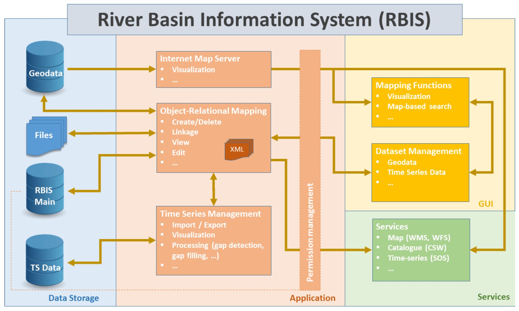
Overview

Hindeke Basin Information Management System (BIS) is a comprehensive tool or framework designed to collect, manage, analyze, and disseminate information related to river basins or watersheds. It plays a crucial role in water resources management, environmental conservation, and sustainable development. The system integrates various data sources, technologies, and analytical tools to provide stakeholders with a holistic view of the basin’s characteristics, dynamics, and trends.

Here are key components and features typically found in a Basin Information System:

  1. Data Collection:
    • Hydrological Data: Includes information on precipitation, river flow, groundwater levels, and other hydrological parameters.
    • Meteorological Data: Covers weather conditions, temperature, humidity, wind speed, and other atmospheric variables.
    • Geospatial Data: Utilizes Geographic Information System (GIS) data for mapping and analyzing spatial relationships within the basin.
    • Land Use/Land Cover Data: Describes the types and distribution of land use and land cover within the basin.
  2. Database Management:
    • Centralized Database: A central repository for storing, organizing, and managing diverse data sets.
    • Data Standardization: Ensures consistency in data formats, units, and metadata, facilitating interoperability and data exchange.
  3. Modeling and Simulation:
    • Hydrological Models: Employed to simulate water flow, runoff, and other hydrological processes within the basin.
    • Water Quality Models: Predict the impact of land use, pollution sources, and other factors on water quality.
    • Scenario Analysis: Enables the exploration of various scenarios to assess the potential impacts of different management strategies.
  4. Decision Support System (DSS):
    • Risk Assessment: Helps in evaluating potential risks such as floods, droughts, and pollution events.
    • Scenario Planning: Assists decision-makers in developing and evaluating different management scenarios.
    • Optimization Tools: Support decision-making by identifying optimal solutions based on predefined criteria.
  5. Data Visualization and Reporting:
    • Graphs and Charts: Visual representation of data trends and patterns.
    • Maps: GIS-based maps to display spatial information.
    • Reports: Generation of comprehensive reports summarizing key findings and recommendations.
  6. Stakeholder Engagement:
    • Public Access: Provides a platform for the public to access relevant information about the basin.
    • Collaboration Tools: Facilitates communication and collaboration among various stakeholders, including government agencies, NGOs, and local communities.
  7. Real-Time Monitoring:
    • Sensor Networks: Integration of real-time data from monitoring stations to provide up-to-date information.
    • Early Warning Systems: Alerts and notifications to relevant authorities and communities in case of potential risks.
  8. Adaptive Management:
    • Feedback Mechanisms: Allows for the incorporation of new data and feedback into the decision-making process.
    • Continuous Improvement: Regular updates and improvements to the system based on lessons learned and emerging technologies.
  9. Water Use Permit:
    • This component facilitates the issuance, tracking, and enforcement of water use permits, ensuring that water extraction and usage adhere to regulatory guidelines and contribute to sustainable water management.

The key benefit of this system is to foster sustainable water resource management, environmental conservation, and resilience to changing conditions within the basin.

Decision Support System Components (Models)

I. Water Balance Modeling

A Basin Information System (BIS) Water Balance Component is a critical element of water resource management, providing a comprehensive understanding of the water dynamics within a specific basin or watershed. The primary purpose of this component is to assess the inflows, outflows, and overall water availability in a basin. Here is a brief overview of key aspects:

  1. Data Collection and Monitoring:
    • Involves gathering data on precipitation, evaporation, surface water runoff, groundwater recharge, and other relevant hydrological parameters.
    • Utilizes weather stations, stream gauges, soil moisture sensors, and other monitoring devices to collect real-time data.
  2. Inflows:
    • Quantifies the input of water into the basin, primarily through precipitation.
    • Considers other sources such as inflow from upstream catchments, tributaries, and external water transfers.
  3. Outflows:
    • Examines various pathways through which water leaves the basin, including surface water discharge, evaporation, and groundwater withdrawals.
    • Evaluates water losses through human activities, such as irrigation and industrial use.
  4. Storage and Reservoirs:
    • Accounts for water stored in natural reservoirs like lakes, wetlands, and aquifers.
    • Monitors artificial storage facilities, such as dams and reservoirs, and assesses their impact on the water balance.
  5. Water Use and Allocation:
    • Tracks the distribution and consumption of water for agricultural, industrial, municipal, and ecological purposes.
    • Identifies trends and patterns in water usage to inform sustainable management practices.
  6. Spatial and Temporal Analysis:
    • Utilizes Geographic Information System (GIS) tools to analyze spatial patterns of water distribution and identify areas of surplus or deficit.
    • Considers seasonal variations and long-term trends to understand temporal dynamics.
  7. Modeling and Simulation:
    • Implements hydrological models to simulate water balance components and predict future scenarios.
    • Incorporates climate change projections to assess potential impacts on water availability.
  8. Reporting and Decision Support:
    • Generates reports and visualizations to communicate water balance information to stakeholders.
    • Supports decision-making processes by providing insights into water availability, potential risks, and recommended management strategies.
  9. Integration with Other Components:
    • Collaborates with other components of the Basin Information System, such as water quality monitoring and environmental assessments, to provide a holistic view of basin health.
  10. Adaptive Management:
    • Enables adaptive management strategies based on continuous monitoring and assessment, ensuring that water resource management practices can evolve in response to changing conditions.

In summary, the Water Balance Component of a Basin Information System plays a crucial role in understanding, managing, and sustaining water resources within a specific geographic area. It aids in informed decision-making for water resource planners, policymakers, and stakeholders to promote sustainable water use and environmental conservation.

II. Water Allocation Modeling

The Water Allocation Model Component within a Basin Information System (BIS) is a specialized tool designed to assess, plan, and manage the distribution of water resources within a given basin or watershed. This component helps optimize water allocation to various users, considering environmental, social, and economic factors. Here’s a brief overview of its key features:

  1. Resource Assessment:
    • Collects and integrates data on water availability, including surface water and groundwater sources, as well as precipitation patterns.
    • Incorporates historical data and trends to understand the variability in water resources.
  2. Stakeholder Input:
    • Involves stakeholders in the allocation process, considering the needs and priorities of different water users, such as agriculture, industry, municipalities, and environmental conservation.
  3. Legal and Regulatory Compliance:
    • Incorporates legal and regulatory frameworks governing water use to ensure that allocations align with established policies, permits, and water rights.
  4. Scenario Analysis:
    • Allows for the simulation of various scenarios to assess the impact of different water allocation strategies under changing conditions, such as population growth, climate change, or land-use patterns.
  5. Optimization Algorithms:
    • Utilizes optimization algorithms to allocate water resources efficiently, considering competing demands and maximizing the overall benefit to society while minimizing conflicts.
  6. Environmental Considerations:
    • Integrates ecological requirements to ensure that water allocations support environmental sustainability and the health of aquatic ecosystems.
    • Considers flow regimes necessary for maintaining habitat integrity, supporting biodiversity, and preventing ecosystem degradation.
  7. Real-Time Monitoring:
    • Incorporates real-time monitoring data to adaptively manage water allocations based on current conditions, improving responsiveness to dynamic factors.
  8. Risk Assessment:
    • Identifies potential risks associated with water allocation decisions, such as over-extraction, water quality degradation, or impacts on downstream users, and proposes mitigation strategies.
  9. Public Awareness:
    • Facilitates transparency by communicating water allocation decisions to the public, fostering awareness and understanding of the rationale behind resource distribution.
  10. Integration with Other Components:
    • Collaborates with other BIS components, such as the Water Balance Model and Water Quality Model, to provide a holistic view of basin dynamics and ensure coordinated management.
  11. Adaptive Management Framework:
    • Adopts an adaptive management approach, allowing the model to be updated regularly based on new data, changing conditions, and improved understanding of the basin’s hydrology.
  12. Decision Support System:
    • Provides decision support tools that allow water managers and policymakers to explore alternative scenarios, evaluate trade-offs, and make informed decisions for sustainable water allocation.

In summary, the Water Allocation Model Component of a Basin Information System is a crucial tool for optimizing the use of water resources, balancing the needs of various stakeholders, and promoting sustainable water management practices within a basin or watershed.

III. Climate Modeling

The Climate Modeling Component within a Basin Information System (BIS) is a vital element that focuses on understanding and predicting climate patterns within a specific basin or watershed. This component employs advanced modeling techniques to assess the potential impacts of climate change on hydrological processes, precipitation patterns, and overall water resource availability. Here’s a brief overview of its key features:

  1. Climate Data Integration:
    • Gathers historical climate data, including temperature, precipitation, humidity, and wind patterns.
    • Utilizes climate models to integrate observational data and generate future climate scenarios.
  2. Downscaling Techniques:
    • Applies downscaling methods to refine global climate model outputs at a regional or basin scale, providing more accurate and detailed information for localized assessments.
  3. Climate Change Projections:
    • Generates future climate scenarios to project potential changes in temperature, precipitation, and extreme weather events.
    • Considers different greenhouse gas emission scenarios to assess a range of possible future conditions.
  4. Hydrological Impact Assessment:
    • Evaluates the impact of projected climate changes on hydrological processes, such as river flow, snowmelt, and groundwater recharge.
    • Assesses the implications for water availability and quality within the basin.
  5. Extreme Events Analysis:
    • Analyzes the likelihood and intensity of extreme climate events, including floods, droughts, and storms, to enhance preparedness and resilience planning.
  6. Sensitivity Analysis:
    • Conducts sensitivity analyses to identify key climate variables and parameters influencing the basin’s hydrological response, aiding in the understanding of system vulnerabilities.
  7. Integration with Water Models:
    • Integrates climate modeling outputs with other BIS components, such as water balance models and water allocation models, to provide a comprehensive understanding of the basin’s water dynamics.
  8. Uncertainty Assessment:
    • Quantifies uncertainties associated with climate models and projections, allowing decision-makers to consider a range of possible future scenarios.
  9. Adaptation Strategies:
    • Provides information on potential adaptation strategies to cope with the anticipated impacts of climate change on water resources.
    • Offers insights into infrastructure planning, water management practices, and policy adjustments.
  10. Communication of Findings:
    • Translates complex climate modeling results into understandable and actionable information for stakeholders, policymakers, and the public.
  11. Continuous Updating:
    • Adopts a dynamic approach, continuously updating climate models based on new data and improved modeling techniques to enhance accuracy and reliability.
  12. Collaboration with Climate Scientists:
    • Collaborates with climate scientists, meteorologists, and other experts to ensure the incorporation of the latest scientific knowledge and methodologies into the climate modeling component.

In summary, the Climate Modeling Component of a Basin Information System is instrumental in assessing the potential impacts of climate change on water resources, providing essential information for adaptive and sustainable water management within the basin or watershed.

Water Quality Management

framework designed to monitor, assess, and manage the quality of water resources in various environments. The main goal is to ensure the protection of water quality for both environmental sustainability and human health. Here are key components and features commonly found in Water Quality Management Systems:

  1. Data Collection:
    • Mobile App Data Collection: Let the data collector personnel enter data using the mobile app.
  2. Data Integration and Management:
    • Centralized Database: Establish a centralized database to store and manage collected data, ensuring easy access and retrieval.
  3. Monitoring and Analysis:
    • Real-time Monitoring: Implement continuous, real-time monitoring to promptly detect and respond to sudden changes or pollution events.
    • Statistical Analysis: Use statistical methods and data analysis techniques to identify trends, patterns, and correlations in water quality data.
  4. Modeling and Simulation:
    • Water Quality Models: Utilize mathematical models to simulate the behavior of water quality parameters under different scenarios, aiding in predictive analysis.
    • Hydrodynamic Models: Integrate hydrodynamic models to understand the movement and dispersion of contaminants within water bodies.
  5. Reporting and Visualization:
    • Dashboard and Reporting Tools: Develop user-friendly dashboards for stakeholders to visualize water quality data, trends, and alerts.
    • Automated Reporting: Implement automated reporting tools for regulatory compliance and to keep stakeholders informed.
  6. Alerts and Notifications:
    • Automated Alerts: Set up automated alert systems to notify relevant authorities and stakeholders in case of abnormal water quality conditions or regulatory violations.
  7. Regulatory Compliance:
    • Compliance Monitoring: Ensure that the system is designed to monitor and report compliance with local, regional, and national water quality standards and regulations.
    • Documentation and Reporting: Facilitate the documentation and reporting required for regulatory compliance.
  8. Decision Support System:
    • Decision-Making Tools: Provide decision-makers with the tools and information necessary to make informed decisions about water resource management.
    • Scenario Analysis: Enable scenario analysis to evaluate the potential impact of different management strategies on water quality.
  9. Public Outreach and Education:
    • Public Access to Information: Establish mechanisms for public access to certain water quality information to enhance transparency.
    • Education and Awareness Programs: Implement programs to educate the public about water quality issues and encourage participation in conservation efforts.
  10. Adaptive Management:
    • Continuous Improvement: Design the system to be adaptable and open to continuous improvement based on feedback, new data, and evolving environmental conditions.